Chennai Rains 2021: What Led To Overnight Rains & Flash Floods?
The MET Department and Tamil Nadu government came under scanner due to the delayed prediction of overall rainfall and lack of adequate monsoon preparedness which reportedly led to the floods.

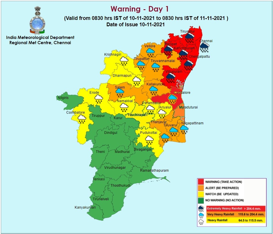
Chennai: On Sunday, Chennai received the highest rainfall of 215.3 mm since the deluge in 2015, leading to waterlogging and inundation of homes, and the India Meteorological Department (IMD) issuing a red alert. The Tamil Nadu government immediately called the National Disaster Response Force (NDRF) and started relief operations.
However, the rains did not stop with Sunday and the Met department predicted the rainfall to be at its peak by Thursday (November 11) due to the formation of a low-pressure area which is likely to intensify into a deep depression on Thursday.

The Met department and the Tamil Nadu government have come under the scanner due to delayed prediction of the rainfall and the lack of adequate monsoon preparedness.
The rains have also raised concern over the changes in the global weather patterns, which is giving rain above 200 mm for the second time since 2015.
Also Read | ‘Return Of The Nightmare?’, Torrential Rains, Flash Floods Remind Chennai Residents Of 2015 Deluge
Why Did Chennai Recieve Rainfall Above 200 mm?
Tamil Nadu receives rains in November mainly due to the onset of the Northeast Monsoon. The rains on Sunday were also due to the Northeast Monsoon which led to a formation of a low-pressure area in the Bay of Bengal. Even in the previous years, the rains were caused due to the Northeast Monsoon and factors like the formation of low pressure but it did not lead to flash floods or inundations.
Climate Trends India, a climate communication initiative, said, "Tamil Nadu along with coastal Andhra Pradesh is gearing up for another round of heavy to extremely heavy rains. As per meteorologists all the prime oceanic parameters--La Nina, Indian Ocean Dipole (IOD) and MJO (Madden–Julian oscillation) -- are currently in favorable positions at the same time favouring the formation as well as strengthening of the weather systems in the Bay of Bengal."
All the more, there are also links between the ongoing rains and climate change, according to Climate Trends. The few changes triggered by climate change are:
- The rise in global temperatures has increased the frequency of heavy rains.
- Global Warming has increased sea level rise by 10%-15% across the Indian seas.
- This coupled with heavy rainfall can amplify the damage.
- The Indian Ocean is also warming at a faster rate with sea-surface temperatures (SST) soaring above average which is favourable for cyclogenesis and there are possibilities for an increase in the shelf life of low-pressure areas over the land.
While all the reasons provided by Climate Trends are long-term issues leading to the change in weather conditions, there are also other mistakes on the part of the Regional Meteorological Centre (RMC), which led to the sudden rains.
Mistakes by RMC
On Sunday, after the overnight rains that battered the city, state officials were upset over the failure of the Regional Meteorological Department to alert the state authorities about the sudden rains.
A report in The New Indian Express said that the failure to give any alert was due to technical issues with the radar at the National Institute of Ocean Technology (NIOT). The radars of Karaikal were also broken leaving the stretch between Puducherry to Thoothukudi dark.
This was not the only issue. The IMD and the RMC also gave different predictions on Saturday. The IMD gave an orange alert to the state, instead of a red alert. Also, RMC, which was trusted with specifying the areas that will be affected in the state, did not provide any alert as the radar failed, The News Minute reported.
Related Video
Tamannaah opens up on making her Tamil digital debut with 'November Story' | SBS Originals


