


Explorer
In Pictures: The ABCs of Earth Taught Through 26 Old Images From Space Shared By NASA
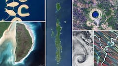
NASA Earth Observatory in a 2015 photo story tracked down all 26 letters of the English alphabet using satellite imagery and astronaut photography. Here is a look at the 26 images.

Imagine exploring the vast landscapes of Earth from space and finding the letters of the alphabet hidden in clouds, rivers, and mountains. That's exactly what NASA Earth Observatory did. Using satellite imagery and astronaut photography, they embarked on an epic quest to track down all 26 letters of the English alphabet, embedded in the natural and ephemeral features of our planet. From the swirling dust clouds forming an "S" to the sharp bends of rivers shaping a "Y", each letter presents a moment of discovery.
1/26
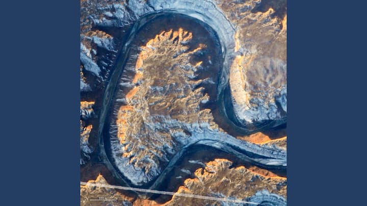
'A' IN THE CURSIVE: On January 22, 2014, an astronaut aboard the International Space Station photographed Utah's Green River as it looped back on itself, showcasing a striking geological feature called Bowknot Bend. Photo: NASA
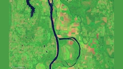
2/26

BEAUTIFULLY GREEN: On August 4, 2014, Landsat 8’s Operational Land Imager (OLI) snapped this shot of the Arkansas River winding through the Holla Bend Wildlife Refuge. During the winter, the refuge often becomes home to 100,000 ducks and geese. Photo: NASA
Published at : 25 Sep 2024 06:43 PM (IST)


View More
Trending News
Top Headlines
World

Trump Posts First Image Of Captured Nicolas Maduro Aboard US Warship
Sports

'If They Release Me...': Mustafizur Rahman Breaks Silence Over IPL Contract Retraction
World

Who Is Cilia Flores? Maduro’s Wife And Power Broker Captured In US Venezuela Strike
Cities

Ajit Pawar Targets BJP, Creates Friction Within Ruling Mahayuti Ahead of Maharashtra Civic Polls


Nayanima Basu
Opinion